Concord, Massachusetts Route 2 Rotary Design
The Bruce Freeman Rail Trail will cross Route 2 near the State Police Barn. There are two design alternatives: to build a bridge over Route 2 or a tunnel could be built to go under it. Below are two documents one showing the "over" design, the other showing the "under" design.
BFRT Over Design (PDF) BFRT Under Design (PDF)
- We have reviewed the four options for the BFRT crossing of Route 2
including:
- BFRT Over Route 2 in the vicinity of the existing railroad right
of way
- BFRT Under Route 2 in the vicinity of the existing railroad right
of way
- BFRT running along the proposed relocated Commonwealth Avenue
bridge over Route 2 and along the north side of Route 2 and over
Nashoba Brook before connecting into the existing railroad right
of way
- BFRT running along the proposed relocated Commonwealth Avenue
bridge over Route 2 and along Route 2A to Wetherbee Street before
connecting into the existing railroad right of way
- BFRT running along the proposed relocated Commonwealth Avenue
bridge over Route 2 and along the north side of Route 2 would require
an additional bridge crossing of Nashoba Brook and additional
wetland impact. BFRT running along Rte 2A would require
additional right of way and wetland impacts. These two options have
been dropped from further consideration because of the additional
wetland and right of way impacts but will be included in the
evaluation as part of the Environmental Impact Report.
- Both the BFRT over and under Route 2 options have been advanced to
the 10% level at this time and are proof of concepts only. Once a
decision has been made as to which is the preferred crossing
alternative, the design will be further refined. Cost estimates are
not developed at this time.
- The option of going over Route 2 has the least impact to Route 2
itself. Route 2 is in a dip at this point and would remain so as the
trail goes up and over Route 2 and Nashoba Brook at this location.
The fill slopes at each end of the bridge would be between 450 and 500
feet long at 4.5% profile slopes, with the bridge itself being between
400' and 450' long.
- The option of going under Route 2 will be almost hidden from Route
2 and Route 2 will be screened from the trail. The approaches to
the tunnel will generally follow the existing ground and Route 2
would be raised in this area. The tunnel would be between 16'
and 20' wide with a height of between 10' and 12'. This option would
utilize a reconstructed railroad bridge over Nashoba Brook.
Contact Grace Arthur if you have questions or comments.
Grace Arthur,
Project Manager
Massachusetts Highway Department
617-973-8251
Grace.Arthur@mhd.state.ma.us
Additional information about the Route 2 Rotary project is available on here
http://www.route2concordrotary.com/
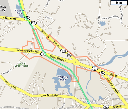
The orange outline indicates the limits of the Rt. 2 Rotary reconstruction.
The green line shows the Bruce Freeman Rail Trail.
|